The iwi of Whakatipu
Why the head of the lake mattered
Ngāi Tahu, Kāti Māmoe and Waitaha all travelled and worked this region over many centuries, for the resources it held.1 At the head of Lake Whakatipu were the precious pounamu sources.1 The wealth of pounamu in the Routeburn and Dart valleys made the area important enough that almost every significant landmark on the journey to the head of the lake carries a name.1
The archaeology agrees. The Upper Whakatipu is one of the concentrations of pre-European settlement in Central Otago, with about thirty prehistoric sites recorded.2 Two proven collecting areas, the lower Routeburn and the Dart River source, are registered as archaeological sites in their own right.2 The stone was worked here as well as gathered: 51 per cent of the artefacts found near Glenorchy are nephrite, as adzes, chisels, awls and partly worked pieces.2
Reporting the 1967 Glenorchy excavations in 1972, the Courier put the first exploration of the Routeburn for greenstone at about AD 1200 to 1400.3 The same report described the foundations of a complete village of twenty dwellings, planned on split levels with paved pathways between the houses, dated to the late fifteenth or early sixteenth century.3 Miller called it the only village of its kind so far discovered in New Zealand, closer in character to places in Samoa than to anything nearby, and quoted Simmons on it: “I just don’t know the reasons for its unique character”.3
A year’s food, and the routes to it
Tī, the cabbage tree, gave a sweet starch; tikumu, the mountain daisy, gave leaves for highly valued cloaks and for leggings that protected against matagouri and speargrass.1 The food year was seasonal and specific: tuna (eels) and other native fish in summer, and winter trips for weka, when the birds were fat.1
The rivers carried people as well as food. The Shotover was Kimiākau, part of the network of kāinga mahinga kai, food-gathering places, and travel routes through Central Otago; the name means “looking for the sea coast”, which is what those trails were for.1 The Kawarau linked the lake to Mata-au, the Clutha, and was crossed near Roaring Meg by a natural rock bridge, Pōtiki-whata-rumaki-nao, until the floods of 1878 destroyed it.1 To the north-west, the Routeburn (Te Komama), Te Awa Whakatipu (the Dart) and the Hollyford formed the well-known route through to Martins Bay, Whakatipu Waitai, one of the largest Ngāi Tahu settlements in the region.1
Where people lived
The kāinga sat on the flat land. Queenstown Bay was Tāhuna, a shallow sandbank or sandy shore; what is now the Gardens peninsula was a small settlement, Te Karoro; Queenstown Hill was Te Tapu nui, signifying its intense sacredness.1 Kāti Māmoe had a settlement on the Frankton flats, Te Kirikiri, kirikiri meaning gravel, and another, Tititea, on the south side of the Kawarau.1 At the far end of the lake, the flat where Kingston now stands was Takerehaka, the site of a kāinga.1 Put those on a road map and you get the town centre, the Gardens, Frankton and the Kingston flat: the same few pieces of sheltered flat everyone has wanted here since.
The record reaches beyond the settlements. At an 1879 Royal Commission of Inquiry into Ngāi Tahu land claims, kaumātua recorded the Hector Mountains, Tāpuae O’Uenuku, as a kāinga mahinga kai where weka and tikumu were gathered.1
The maps Māori drew
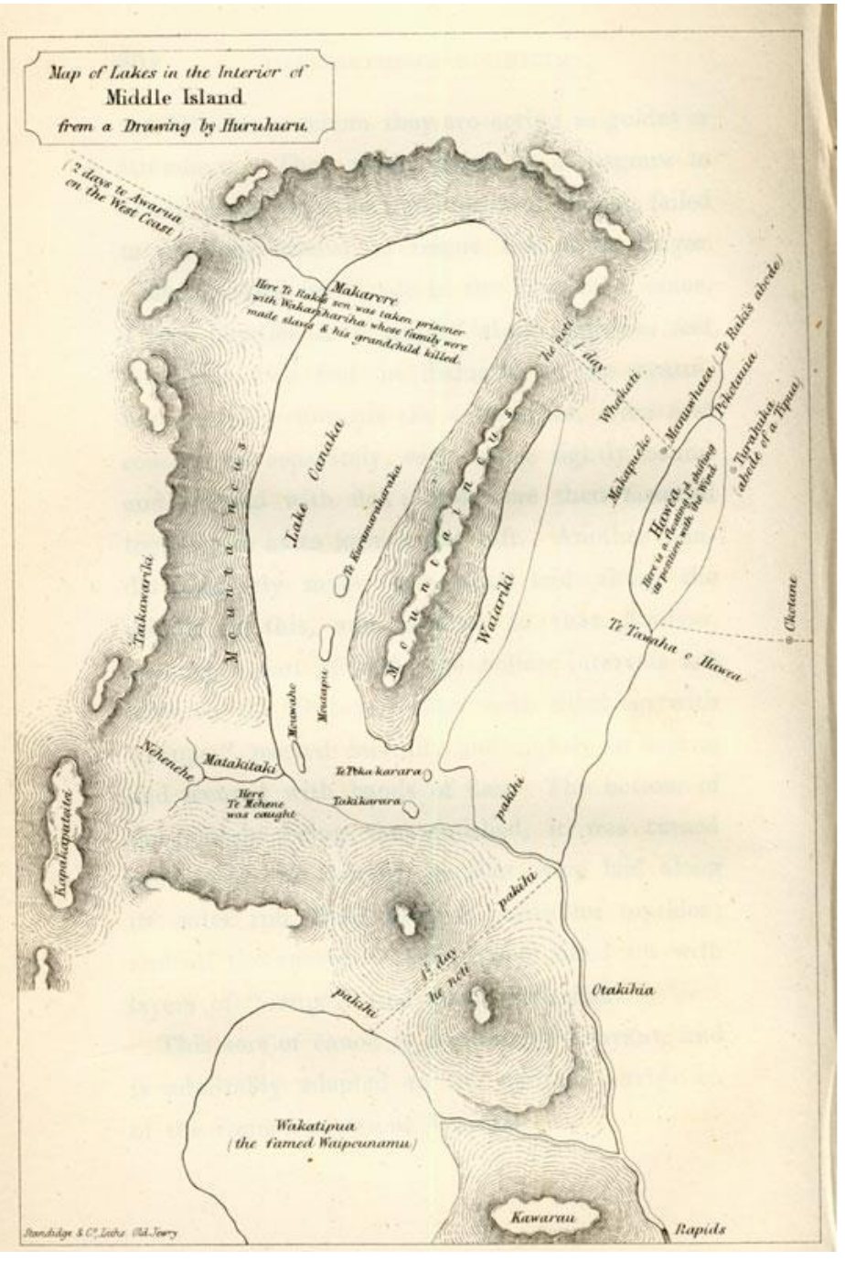
Pākehā knew of this country before they saw it, because Māori described it to them. In January 1844 Edward Shortland waited with Te Huruhuru at the Waitaki, and in the evenings Te Huruhuru drew the outline of four lakes in pencil and told him that one, Whakatipu, “is celebrated for the ‘pounamu’ found on its shores”.1 Shortland published that drawing as a map in 1851.1 In September 1853 Nathaniel Chalmers, guided by Reko and Kaikōura, travelled north from Tuturau, and at the summit of the Nevis valley became the first European to see the lake.1 Three years later a map drawn by Reko guided John Chubbin to the southern end of it. Chubbin described Reko drawing him the course of the Mataura in sand with a stick, the streams as hollows and the mountains as little mounds.1
Still there when the sheep came
Seasonal visits were still happening in the nineteenth century.1 In The Wakatipians, Alfred Duncan records that at the head of the lake his party found traces of Māori: stake nets, baskets for catching eels, spears, and ashes.1
The country the first runholders took up was not empty. The passes, the river lines and the flat ground worth camping on had been named and worked for centuries, and much of it had already been drawn for Pākehā by Māori. Some of those names are still on the signs. The rest survive because somebody wrote them down and the Society keeps reprinting them, and in the Ngāi Tahu Atlas.
More from Māori History & First Colonists
Sources
- 'Māori Placenames in the Wakatipu, by Pauline Lawrence', Queenstown Courier No. 104, p. 18-23 (index)
- 'Archaeology & Prehistory of the Upper Wakatipu Region, by Neville Ritchie', Queenstown Courier No. 25, p. 13-18 (index)
- 'Fragments of Pre-European History at the Head of Lake Wakatipu, by A. M. Miller', Queenstown Courier No. 8, p. 6 (index)